written by former student, Jordan Byrnes
Geology is the science that deals with the Earth’s physical structure and substance, its history, and the processes that act on it.
Geology guides humans in the search for fuels and minerals, assists engineers in designing and constructing structures to improve our environment, helps agriculturists interpret soil conditions, and aids tourists in understanding an area’s natural features. Kentucky has a diverse geological story. Interesting pages of the Earth’s history are revealed in the majestic mountains, rocky gorges, cascading waterfalls, picturesque caverns, broad valleys, fertile plains, and quiet glens. Natural Bridge State Resort Park and Red River Gorge Geological Area are unrivaled in the eastern United States for their number of natural sandstone arches and bridges. Cumberland Falls is one of the largest waterfalls in the Southeast. Mammoth Cave National Park contains the longest mapped cave system in the United States. The Jackson Purchase region was once part of a much larger Gulf of Mexico.
Types of rocks
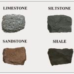
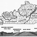
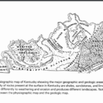
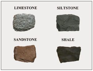
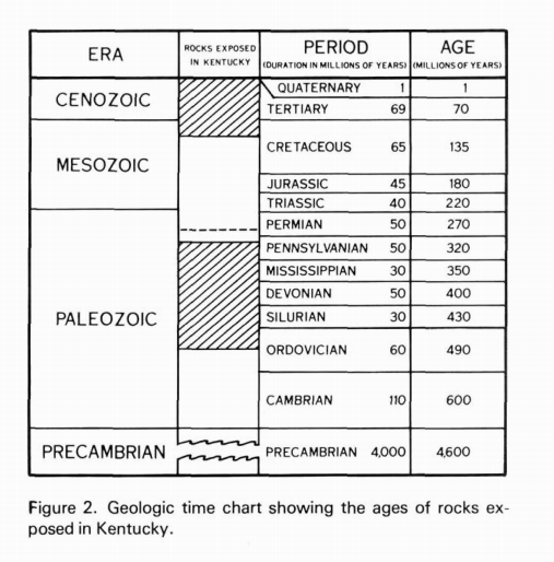
One cannot cross Kentucky, either east to west or north to south, without noticing changes in rock types in road cuts and hillsides. From Lexington to Paducah, one would traverse four major geologic regions and could observe rocks of eight major geologic periods. For a person who understands the geologic features, an excursion across Kentucky can be more than a sightseeing tour. The spectacle of changing landscapes becomes an adventure into the geologic mystery of the past and the scenic beauty of the present. Most of the surface rock formations are sedimentary, and they are generally layered like a cake. Granites and metamorphic rocks are deeply buried. There is no evidence of volcanoes. The geologic story of the rocks now exposed in Kentucky began approximately half a billion years ago when the area was covered by a great body of water. There have been frequent changes in sea levels over Kentucky, which are reflected in types of rock and nature of animal and plant life associated with them. Various muds, sands, shell fragments, and lime oozes accumulated on ocean bottoms much as they do today. Mud became clay and shale. Loose sand and silt became sandstone and siltstone. Gravels became conglomerates. Shells, shell fragments, lime oozes, and chemical precipitates became limestone.
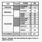
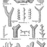
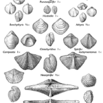
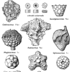
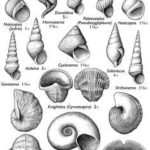
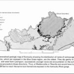
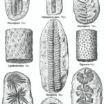
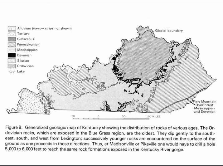
The oldest rocks exposed at the surface of the ground in Kentucky are hard limestones of Middle Ordovician age (450-470 million years old). They are found along the Kentucky River gorge in central Kentucky between Boonesboro and Frankfort. Older rocks are present in the subsurface, but can be seen only in drill cuttings and cores taken from oil and gas drilling and mineral exploration. Later in Ordovician time, the seas became relatively shallow, as indicated by the amount of mud (shale) in the sediments. When the waters were clear and warm, a profusion of animal life developed, particularly brachiopods and bryozoa. These are the rich fossil beds which have attracted amateur and professional paleontologists to the stream beds, rocky hillsides, and road cuts of the Outer Blue Grass.
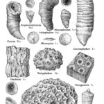
Limestone formations of Devonian age are thin in Kentucky but may contain brachiopods, crinoids, and corals. Before the end of Devonian time, the sea floor became covered with an organic black muck. This muck is now a hard black shale (an oil shale) which is one of the most distinctive of all geological formations in Kentucky. It is easily recognized by its black color and thin, hard, brittle layers. Fossil remains of the earliest known trees have been found in this formation. When Mississippian seas cleared (358 to 323 million years ago), thick layers of limestone were deposited in the warm, shallow waters. Brachiopods, bryozoa, corals, and crinoids were common forms during that geologic time period. The seas receded briefly at the end of the Mississippian Period, as indicated by the uneven, eroded surface on which subsequent Pennsylvanian sediments were deposited.
During the Pennsylvanian Period (323.2 million years ago to 298.9 million years ago) parts of Kentucky were covered intermittently by shallow seas. The climate was warm, and extensive forests grew in great coastal swamps at the edge of the water. Marine waters advanced and receded many times. Grasses, reeds, and trees grew in these lush forests. Vegetation of all sorts fell into the water and was buried under blankets of clays, silts, and sands. Clay sealed the vegetation from oxygen, preventing decay. The weight of sediments over long geologic time compressed vegetation into coal. The process was repeated many times, thus accounting for the numerous coal beds in Kentucky’s two coal fields. A series of uplifts followed the Paleozoic Era in Kentucky. Seas receded and the land became dry for a long period of time. Much of Kentucky’s landscape is a product of erosion that began at that time. During the latter part of the Cretaceous Period, the Gulf of Mexico inundated much of the southern United States. A long bay extended northward from the Gulf, covering all of the Jackson Purchase and adjacent portions of the Mississippian Plateaus with sands, clays, and gravels.
Fossil fuels and mineral resources are very important to the economy of Kentucky. They are widely distributed in Kentucky, being produced in approximately 100 of Kentucky’s 120 counties. Coal is produced in 44 counties, petroleum in 59 counties, and limestone in 65 counties. Other mineral commodities include natural gas, clay, shale, sand, gravel, sandstone, rock asphalt, barium, lead, and zinc.
Landscape
Glaciation played only a minor role in the geologic history of Kentucky as compared to our sister states to the north because the southern margin of the continental ice sheet barely crossed the Ohio River. The land surface features largely reflect the kinds of rock which lie beneath them and the effects of weathering and erosion upon these rocks. After layers of sediment were deposited, the area we now know as Kentucky began to be modified by geological processes. Weathering and erosion of surface rocks and deformation by folding and faulting of many strata altered the landscape. Most of the areas underlain by sandstones are either hilly or mountainous because sandstones tend to resist weathering and erosion more than other Kentucky rocks. Caves, sinkholes, sinking creeks, large springs, and other features associated with underground drainage are found in the limestone terranes. Stream erosion has been the predominant geological force sculpting and modifying the Kentucky landscape since the close of the Paleozoic Era.
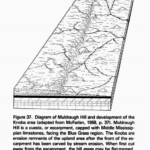
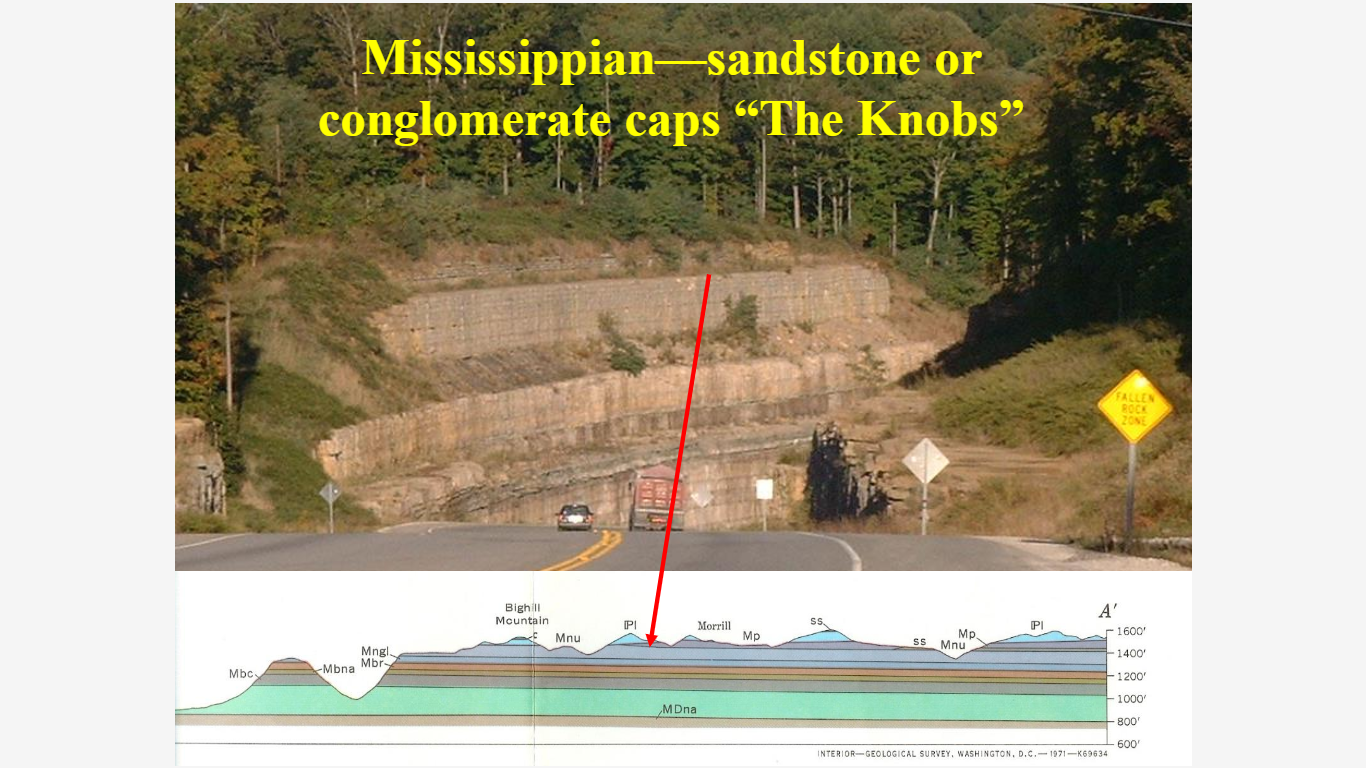
A horseshoe-shaped belt of ridges and hundreds of more or less isolated, rounded, and conical hills border the Bluegrass Region on the west, south, and east. This forested upland area has been referred to as “The Knobs” and constitutes a picturesque and scenic segment of Kentucky’s landscape. The Pinnacles is located in this region. In its typical development, the Knobs area is a narrow belt of hill country characterized by partially or completely rounded hills and conical knobs capped by resistant layers of rock. These knobs often stand out as prominent landmarks. The Knobs are erosion remnants which have been detached from the main upland by stream erosion. When they first become cut off or isolated, they are flat-topped hills or ridges. Further erosion removes the resistant cap and they take on a conical form. These cone-shaped peaks constitute some of the most striking topographic features of the region.
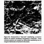
The edge of the Cumberland Plateau is bounded by an escarpment that rises several hundred feet above the adjacent lowland. It contains some of the most scenic areas in Kentucky. Massive, cliff forming sandstones of Early Pennsylvanian age which cap the escarpment and upland are resistant to erosion and produce rugged, picturesque landscape features. Precipitous cliffs, craggy pinnacles, rocky gorges, rock shelters natural bridges, cascading waterfalls, and other natural features abound there. Towering walls of conglomeratic sandstone hem in the narrow drainage valleys with massive ledges and overhanging cliffs. Weathering and erosion have created fascinating etched and pitted patterns in some of the rock. Limestone ledges underlie the sandstones and are the locale of caves, springs, and sinking creeks.

Elevation
Elevations in Kentucky range from a low of 260 feet above sea level on the Mississippi River where it leaves Fulton County in the western part of the State, to 4,145 feet at a peak on Black Mountain in Harlan County near the Kentucky-Virginia border. If sea level were to rise 500 feet, as it undoubtedly did several times in the geologic past, most of the Jackson Purchase would be inundated and Louisville would be a seaport.
As you explore at The Pinnacles, or anywhere in Kentucky, think about the story behind the mountains, gorges, waterfalls, caverns, valleys, and plains you see!
Sources:
McCrain, P. (1983). Geologic s=Story of Kentucky. Retrieved 2018, from https://kgs.uky.edu/kgsweb/olops/pub/kgs/GeoStory.pdf